Live Maps & IONODES PERCEPT Body Camera Real-Time Personnel Tracking in Milestone XProtect
Live Maps & IONODES PERCEPT Body Camera Real-Time Personnel Tracking in Milestone XProtect
Introduction
In modern security operations, knowledge is power – and knowing where your personnel are in real time can be just as critical as seeing what they see. Body-worn cameras have already transformed security and policing by capturing on-the-ground video and audio. Now, with ORBNET Live Maps integrated into Milestone XProtect and IONODES PERCEPT Body Cameras, we’re entering a new era: real-time personnel tracking on your surveillance maps. I remember a few years back, Milestone shared a proof-of-concept video showing live GPS tracking of an object on a map, and our support team was inundated with calls from excited users asking how to get it working. At the time, it was only a concept – but today that vision is a reality. This article explores why real-time personnel tracking is becoming indispensable in security operations, how the ORBNET Live Maps + IONODES integration works, and what it means for situational awareness in scenarios from airports to campuses and public events.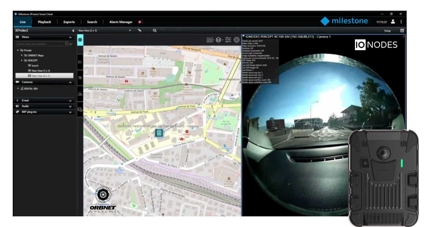
The Growing Importance of Real-Time Personnel Tracking
Not long ago, tracking the live location of security staff was a “nice to have” feature reserved for specialized teams. Now it’s moving into the mainstream of security operations. There are several reasons behind the growing demand for live personnel tracking:
- Enhanced Situational Awareness: When an incident unfolds, knowing exactly where each responding officer or guard is located is invaluable. Real-time tracking gives control room operators a dynamic bird’s-eye view of the scene. They can see, at a glance, which personnel are closest to an incident and how they are moving, enabling better decision-making under pressure.
- Improved Coordination & Response: In fast-moving situations, timing and coordination are everything. With live location data, a supervisor can quickly dispatch the nearest trained responder to an alarm or coordinate multiple personnel from different directions. This minimizes response times and avoids confusion – especially in large, complex facilities where radio calls of “Where are you now?” can slow things down.
- Officer Safety & Accountability: Real-time tracking isn’t just about efficiency; it’s also about safety. If an officer calls for backup or triggers an emergency alarm, the command centre instantly sees their location and can send help to the right place. In extreme cases, if an officer is unresponsive, knowing their last reported position could be lifesaving. Furthermore, having a recorded trail of movements provides accountability – it paints a factual timeline of who went where, which is vital for incident reviews and evidence collection.
- Richer Context for Video Footage: Body-worn cameras already provide crucial visual evidence. When you pair that video with location data on a map, you add a layer of context that stationary cameras can’t provide. For example, if a chase occurs, the bodycam video shows the suspect and surroundings, while the map trace shows the exact route taken through the building or streets. Later, investigators can reconstruct the entire incident with both visuals and a spatial timeline, strengthening the evidentiary value of the footage.
In short, real-time personnel tracking has shifted from a futuristic idea to an operational necessity. As organizations deploy more mobile cameras and IoT devices, integrating those feeds and location data into one cohesive system is the new benchmark for smart security management.
ORBNET Live Maps + IONODES PERCEPT Body Camera: How It Works
So how do we actually bring live GPS tracking of personnel into Milestone XProtect? The answer lies in a powerful combination: ORBNET Live Maps, a cutting-edge GIS mapping add-on for XProtect, and PERCEPT Body Cameras, which provide the live video and GPS data from the field. Here’s a technical breakdown of how these pieces fit together and what capabilities they unlock:
On the ORBNET Live Maps interface, each PERCEPT Body Camera appears as a moving icon on the site map within XProtect. In this example, blue camera icons represent security personnel carrying body cameras, updating their position in real time. The ORBNET Live Maps plugin installs into the Milestone XProtect Smart Client, effectively “powering up” the Smart Client with an interactive map pane. As PERCEPT Body Cameras stream video into XProtect (over Wi-Fi or 4G/LTE), they also transmit their GPS coordinates via ONVIF metadata. Live Maps reads this data and plots each device as an icon on map. Security operators can see the guard’s live position updating continuously – no manual input required. The integration is plug-and-play: any ONVIF-compliant device that sends GPS info (which the IONODES cameras do) can be tracked, without custom development or complex setup. You simply add the body camera into XProtect like any other camera, and Live Maps takes care of the rest.
Crucially, ORBNET Live Maps doesn’t just drop a dot on a map; it ties together video, location, and system events into one unified interface. If an operator wants to see what a particular guard is seeing, they can click on that guard’s icon and instantly pull up the live video feed from the body-worn camera. The map and the video are linked – when the person moves, the icon moves, and the video continues streaming, all within the XProtect Smart Client. This camera feed linking means you’re never more than a click away from visual confirmation of any dot on the map. It transforms the abstract “unit 3 is near Door A” into a concrete view of what’s happening at Door A through the eyes of the responder.
Another game-changing capability is historical playback of movement trails. ORBNET Live Maps can record the location stream from each body-worn camera over time. This means that not only can you monitor movements live, but you can also rewind and replay them. In XProtect’s playback mode, you could review an incident from earlier in the day and watch a little icon tracing the guard’s path through the scene, synced alongside the actual bodycam footage in the timeline. The Live Maps plugin also allows operators to replay a device’s path during incident review. A recorded trail shows where an asset moved over time, with markers indicating historical positions – invaluable for post-incident analysis. Being able to retrace steps after the fact provides deep insights: you can see if patrol routes were followed, how an incident unfolded spatially, or whether any areas were missed during a search. All of this is within the familiar XProtect interface, so investigators can play video and see movement on the map simultaneously without jumping between different software.
Beyond tracking people and linking video, ORBNET Live Maps enhances the overall command-and-control picture by integrating with other security systems and sensors in XProtect. For instance, alarms can be visualised on the map, so when an alarm or a panic button is activated, an icon or flashing indicator can pop up at the exact location on the map. The operator doesn’t have to guess which building or entrance an alert refers to – it’s right there visually. They can then see which camera (fixed or body-worn) is nearest and even who might already be in that area. Live Maps also supports acknowledging alarms directly through the map interface: imagine seeing an alarm indicator on the map, clicking it, and pulling up options to view associated video or mark it as handled – all without switching screens. This tight integration means that cameras, personnel, and alarms aren’t isolated dots of information; they’re part of one cohesive situational awareness display. A guard with a PERCEPT Body Camera might even be shown with a different icon if they send an SOS signal, or the map could highlight their icon and route if an “officer down” alert is triggered. And because ORBNET Live Maps is built to Milestone’s modern standards, it’s scalable and flexible – you can track dozens or even hundreds of devices, and customize how icons and labels appear to avoid clutter. In short, the Live Maps + IONODES PERCEPT Body Camera integration turns XProtect into a real-time personnel tracking centre, combining live video, location, and system events in one place.
Key Features at a Glance: To summarize the capabilities that this integration brings:
- Live GPS Mapping of Personnel: Every IONODES PERCEPT Body Camera becomes a live GPS beacon on your XProtect map. As officers move through an airport terminal, campus, or city streets, their location updates in real time. This gives dispatchers a constantly updated overview of team positions without any manual radio reports.
- Video and Location Synced: Clicking on a person’s icon opens their live video feed, tying together the “where” and the “what.” Operators can observe situations through the bodycam while simultaneously tracking that officer’s movement. This dual context is incredibly useful – for example, watching an officer pursue a suspect through various sectors on the map while viewing the chase from the officer’s perspective.
- Historical Trail Playback: The system logs position data over time. During incident debriefings or investigations, you can replay an individual’s movement trail on the map alongside recorded video. This feature is ideal for reconstructing events (e.g., the path an officer took through a building during a search), verifying patrol patterns, or training purposes (“let’s review how you approached this scenario”).
- Alarm Overlays: Live Maps can overlay other critical data like on the map. If Motion is detected outside of an expected time or a fire alarm goes off, it’s displayed at the correct location on the map in real time. Operators instantly see what’s happening and who is nearby to respond. They can acknowledge alarms through the map and even pull up camera feeds with one click. By visualizing alarms and mobile personnel together, the system provides total situational awareness at a glance.
All of these features work together seamlessly inside the XProtect Smart Client, using the existing infrastructure. The beauty of this approach is that it doesn’t require reinventing your workflow – it enhances it. Your team still uses the Smart Client they know, but now with an interactive mission control map. For the first time, you can truly see your security personnel moving through the environment in relation to cameras, doors, and alarms. It’s a powerful extension of Milestone’s open platform, made possible by ORBNET’s innovative plugin and IONODES’s advanced bodycam technology.
Use Cases: Real-Time Tracking in Action
To appreciate the impact of real-time personnel tracking, let’s walk through a few hypothetical (but very realistic) scenarios. These examples show how Live Maps and IONODES PERCEPT Body Cameras together can elevate situational awareness, improve coordination, and strengthen evidence collection in various environments:
- Airport Security Incident: It’s late at night in a large international airport when an alarm from a restricted access door in Terminal B signals a possible breach. The control room immediately brings up the Live Maps view. A flashing icon on the map shows exactly which door triggered the alarm, and just as importantly, nearby a blue icon indicates a security officer with an IONODES PERCEPT Body Camera is only a hundred feet away. The operator clicks the officer’s icon to verify through the live bodycam feed what’s happening: on screen, a man is seen ducking under the half-open door into a secure area. The operator speaks over the radio (or even through the bodycam’s two-way audio) to direct that officer and simultaneously dispatches two more officers whose locations are updating on the map as they converge on the scene. The intruder is quickly intercepted. Later, when writing the incident report, the security team replays the entire event: the bodycam video of the confrontation alongside the movement trails of all responding officers on the airport terminal map. What could have been a chaotic chase in a huge facility became a tightly coordinated response, with complete situational awareness from start to finish.
- Campus Emergency Response: On a university campus, reports come in of an unauthorized individual spotted near a residence hall, possibly with a weapon. Multiple campus security officers are on duty, all equipped with IONODES PERCEPT Body Cameras streaming back to the campus security centre. As the team scrambles, Live Maps provides an invaluable overview: each officer’s dot is visible moving in real time across the campus map. The security manager can see Officer Smith coming from the north quad, Officer Lee rushing from the library, and Officer Davis already near the residence hall entrance. Via the map, it’s clear that Officer Davis will reach the hall first. The manager opens Davis’s bodycam feed to get eyes on the situation: he sees students being evacuated and a glimpse of the suspect’s location. He guides the other officers around the building using the map – for example, directing Officer Lee to cover the east exit based on their live GPS positions. The suspect is contained and apprehended within minutes. During the aftermath, the value of the integrated system is evident: all officers are safe, their coordinated positions prevented friendly cross-fire or confusion, and the entire operation’s video and location data is saved. The campus police chief uses the replay to both commend the team’s response and to identify a couple of blind spots where coverage could be improved for future incidents.
- Stadium Event – Crowd Management and Incident Investigation: At a sold-out sports event, dozens of security staff are on duty across the stadium, many wearing bodycams. When a fight breaks out in one of the concourses, a patron uses an emergency call point to alert security. Instantly, an alarm appears on the Live Maps screen, pinpointing the section of the concourse. The operations centre sees that two security officers are very close by – their icons (and associated names) are right around that area on the stadium map. Those officers are notified through radio and reach the scene almost immediately, with their bodycams capturing the altercation. Meanwhile, the central operator pulls up one officer’s camera live feed from the map to assess if additional backup or medical aid is needed. Other nearby officers are guided via the map to form a perimeter and manage the surrounding crowd flow. The fight is broken up quickly and the individuals involved are escorted out. Later, when an investigation is conducted (and potential legal action considered by one of the ejected patrons), the security team has a goldmine of evidence: multiple angles of bodycam footage and a synchronized map showing the responders’ exact movements and timeline. The precise mapping even helps clarify claims – one individual argues that security used excessive force unprovoked, but the replay shows the person had actually moved aggressively toward another fan (as seen on video) and the nearest guard’s icon on the map was actively responding to that exact location at that time. The integrated data provides an airtight account of the event, protecting the venue and staff with factual documentation.
These scenarios underscore how real-time personnel tracking isn’t technology for technology’s sake – it directly translates into safer and smarter operations. Whether it’s a sprawling airport, an open campus, or a crowded public event, the ability to see the live picture (who’s where, doing what) makes all the difference. Dispatchers and operators move from reactive to proactive, field teams get better support, and incidents are resolved faster with clearer insight. And beyond the immediate response, the recorded location trails and video serve as a powerful tool for after-action reviews, training, and evidence. Essentially, ORBNET Live Maps plus IONODES PERCEPT Body Cameras turn what could be chaotic incidents into manageable, analysable events.
Closing Thoughts and Next Steps
We’ve come a long way from imagining real-time officer tracking to making it an everyday reality in XProtect. As someone who’s worked with Milestone systems for years, it’s incredibly satisfying to see this integration come to fruition – and to see the “aha” moments when security teams realize what’s now possible. By uniting live video and live mapping, we’re breaking down the old silos between CCTV operators and ground personnel. The result is a level of situational awareness that truly elevates security operations to the next level. You’ll likely find that once you have the ability to follow your team on a map, you’ll wonder how you ever managed without it.
If you’re ready to experience this in your own environment, ORBNET Live Maps is available for download (via the Milestone Technology Partner Finder or ORBNET Systems website) – it’s a plug-in that can be up and running in no time on your XProtect system. IONODES PERCEPT Body Cameras, likewise, are Milestone-certified and primed to feed both video and GPS data right into the platform. I encourage you to give this combination a try: set up a demo, walk around with a bodycam, and watch yourself move on the map in real time – it’s a powerful demo that speaks for itself.
To learn more or get started, you can download ORBNET Live Maps and check out the documentation for integrating IONODES PERCEPT Body Cameras with XProtect. And as always, feel free to reach out to our team for support or a personalized demo. We’re here to help you bring your security operations into this new age of real-time visibility. Stay safe, stay informed, and happy mapping!
Author: Justin Butterworth
Date: July 9th 2025
Original Article